
3-1 Vote Recommends Shifting Landlocked Residential Parcel Near Route 1 and Union Street to Manufacturing Despite East Walpole Flood Concerns
NORWOOD – A majority of the Norwood Planning Board voted on Monday night, November 19, 1979, to recommend that the upcoming December 3 Special Town Meeting approve a petition by brothers William J. and Thomas B. Zoppo of Zoppo Realty Trust to rezone roughly 3.5 acres of landlocked residential property to manufacturing use, rounding out their 26-acre industrial holdings near Route 1 and Union Street. Reported in The Patriot Ledger on Tuesday, November 20, 1979, the 3-1 vote (with one abstention) cleared the way for the Zoppo brothers to potentially develop a small industrial park on the site.
Situated along Traphole Brook near the Crispy Pizza warehouse on Union Street bordering the Walpole town line, the 3.5-acre parcel was zoned for general residence (two-family) housing—a classification the Zoppo brothers argued made no sense alongside the rest of their manufacturing-zoned tract or the adjacent limited manufacturing zone across the border in Walpole. Planning Board Chairman Paul J. Donohue—who had remarked at a July public hearing that the change would “clean up the zoning”—noted that the isolated residential strip was virtually worthless as currently zoned, a view shared by supporting board members E. William Bamber and Richard J. Wisgirda.
Board member Thomas A. Riolo cast the lone dissenting vote, citing “concern for people living in the area,” even while conceding that developing the parcel under general residence zoning was impractical. Member Thomas F. Cavanaugh abstained in order to investigate the parcel further. Opposition also came from across the town border in a formal letter from Robert W. Foster, executive secretary of the Traphole Brook Protection Association of East Walpole, who warned that keeping the Norwood bank zoned residential “gives the brook some protection ecologically” and “protects the citizens of Norwood and Walpole as it is unlikely that the land could be developed to further raise flood stages.” Donohue noted that the Walpole Planning Board had also been notified of the hearing but submitted no response.
In related pre-Town Meeting business on Monday night, the Planning Board:
- Endorsed Flood Plain Zoning Amendment: Voted unanimously to back a new flood plain zoning bylaw amendment required to meet an upcoming federal flood-insurance deadline.
- Released Wellsweep Farms Performance Bond: Determined that developer Robert Rizzo’s 18-lot Wellsweep Farms subdivision off Union Street had been satisfactorily built to town specifications, releasing the $7,000 tri-party performance bond balance pending completion of two minor punch-list items.
- Tabled Use Variance Bylaw: Deferred action on drafting a proposed use variance bylaw until holding a joint session with the Zoning Board of Appeals, which had requested the measure for Town Meeting consideration.
1979 Subdivision Performance Bond Adjusted to 2026 Dollars & Route 1 / Union Street Site Context
Inflation-adjusted using U.S. Bureau of Labor Statistics CPI data ($1.00 in Nov. 1979 ≈ $4.33 in 2026)
| 1979 Norwood Planning Board Subdivision Bond | 1979 Amount | 2026 Equivalent |
|---|---|---|
| Wellsweep Farms (18-Lot Subdivision) Released Bond Balance | $7,000 | ~$30,310 |
Developer Richard Saccone Appeases Norwood Planning Board With Pilgrim Drive Paving at Grandview Estates
Emergency Roadwork Averts Calling In $48,000 Performance Bond as Sidewalk Inspections Are Scheduled
A tense standoff between the Norwood Planning Board and residential developer Richard Saccone ended on friendly terms on Monday night, November 19, 1979, after board members inspected Grandview Estates I and confirmed that Saccone had paved a key stretch of Pilgrim Drive to satisfy municipal subdivision requirements. Reported in The Patriot Ledger on Tuesday, November 20, 1979, the rapid paving progress averted a threatened bond default just two weeks after the Planning Board had voted unanimously—at the urging of member Thomas F. Cavanaugh—to call in Saccone’s $48,000 in performance pledges unless substantial roadwork was completed by Monday’s meeting.
Appearing before the board alongside his Dedham attorney, Roderick O. Ott, Saccone pledged to finish installing sidewalks and remaining punch-list work that week so the subdivision could undergo formal inspection by the Town Engineer’s office early the following week. Even Cavanaugh, who had spearheaded the bond-forfeiture ultimatum, expressed approval: “I’m happy to see” work had been accomplished, adding, “For the time being, I’m satisfied.” Planning Board members noted, however, that the $48,000 performance bond would remain held by the town until final engineering inspection confirmed full compliance.
1979 Grandview Estates Performance Bond Adjusted to 2026 Dollars
Inflation-adjusted using U.S. Bureau of Labor Statistics CPI data ($1.00 in Nov. 1979 ≈ $4.33 in 2026)
| 1979 Subdivision Infrastructure Guarantee | 1979 Bond | 2026 Equivalent |
|---|---|---|
| Grandview Estates I Subdivision Performance Pledge | $48,000 | ~$207,840 |
Archival Note: This article has been dynamically reconstructed from the original public record print archives of the Patriot Ledger
-
1923 Planning Board Report-Existing East-West Through Streets and Diagonals
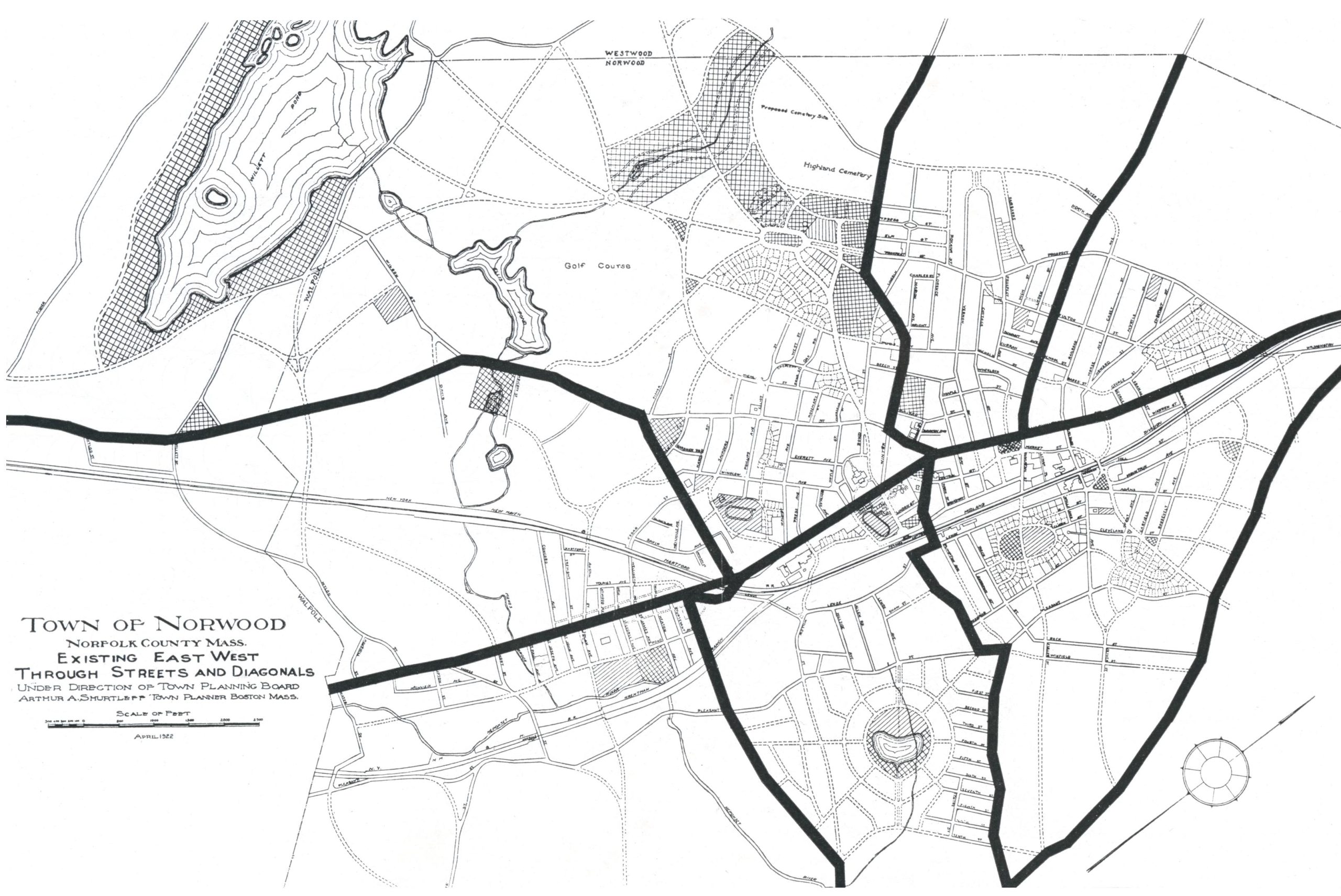
When the main thoroughfares of Norwood were laid out a century or more ago for a convenient approach to fields and pastures and to connect knots of houses or villages with one another, less continuity was secured in the east-west routes than the north-south. As the north-south streets served to connect Boston with Providence and…
-
1923 Planning Board Report-Proposed Additional East-West Through Streets and Diagonals
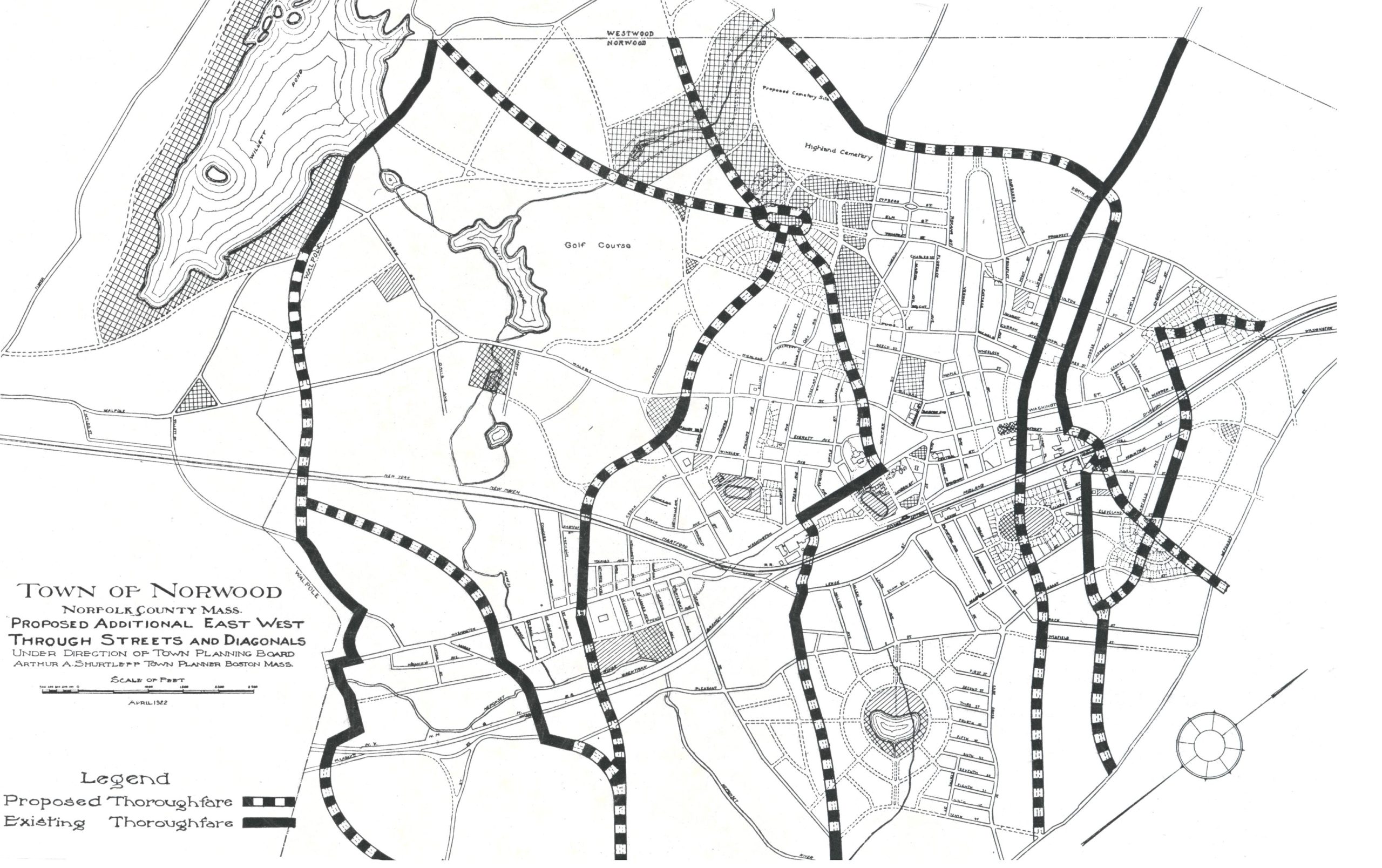
In the wide interspaces between the existing east-west thoroughfares there are many local streets already built, and many more contemplated or actually under construction. Gradually, in a long term of years, all these wild lands will be traversed by roads as the population of the Town increases. These roads will be built by private initiative…
-
1923 Planning Board Report-Existing North-South Through Streets

The existing through streets of Norwood, as shown above, were laid out in times before the construction of the steam railroads, before the large industries were established, and, of course, long before the development of modern housing and the beginnings of motor vehicle transportation. These through streets belong to the epoch of the chaise, the…
-
1923 Planning Board Report-Proposed Additional North-South Through Streets and Diagonals
In the outlying districts of the Town where new houses and new streets are springing up, the individual land owners have used and are still using customary skill and foresight in the planning of individual lots to meet the desires of house builders and to make the lots accessible from the local streets of these…
-
1923 Planning Board Report-Schools, Parks and Playgrounds
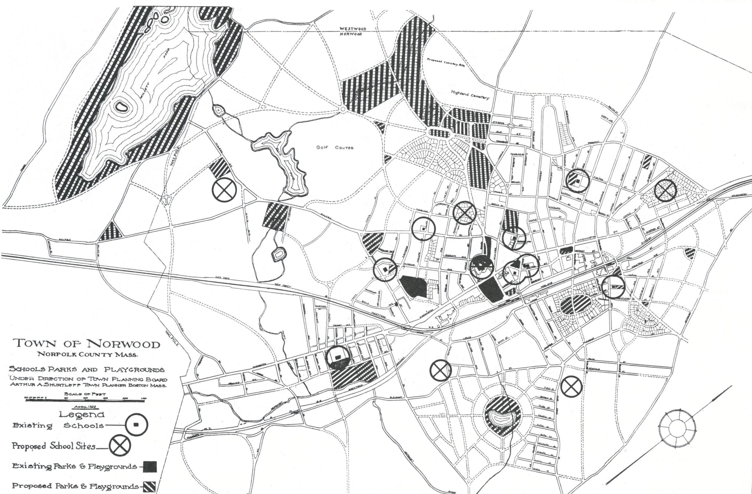
On the accompanying map are shown the public schools of Norwood. They are grouped most closely near the center of the Town with scattered buildings on the outskirts. Evidently school locations will follow the centers of new growth, but the extent to which these structures will be scattered depends upon the policies adopted in the…
-
1923 Planning Board Report-Streets Near Norwood Railroad Station
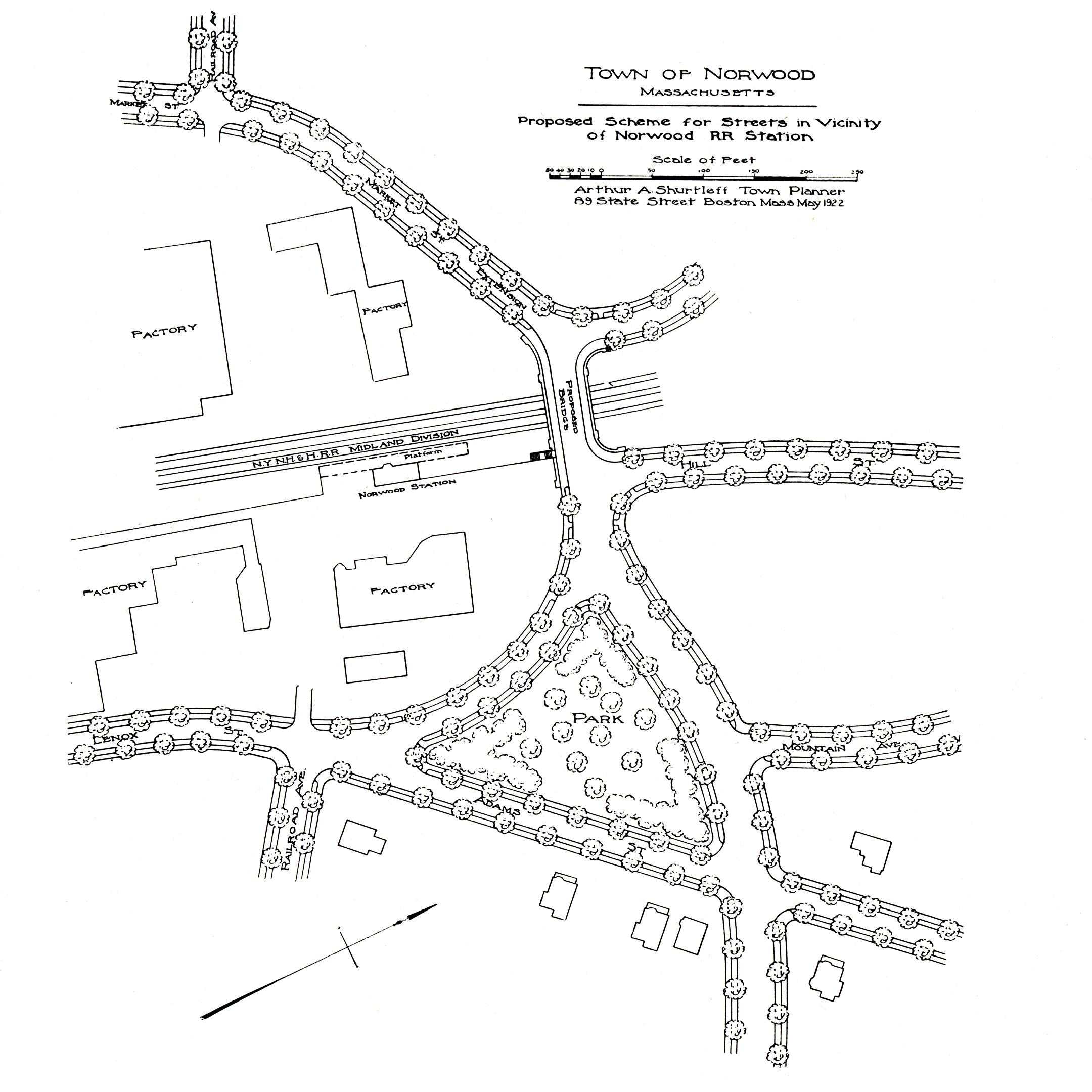
In the course of the general program of the state for the abolishment of railway grade crossings, the present dangerous crossing at Railroad Avenue will be abolished. This work should be undertaken, however, not only with an eye to the safety of persons crossing the tracks, but with consideration of adequate communication across the Town.…
-
1923 Planning Board Report-Development of Clark Swamp District
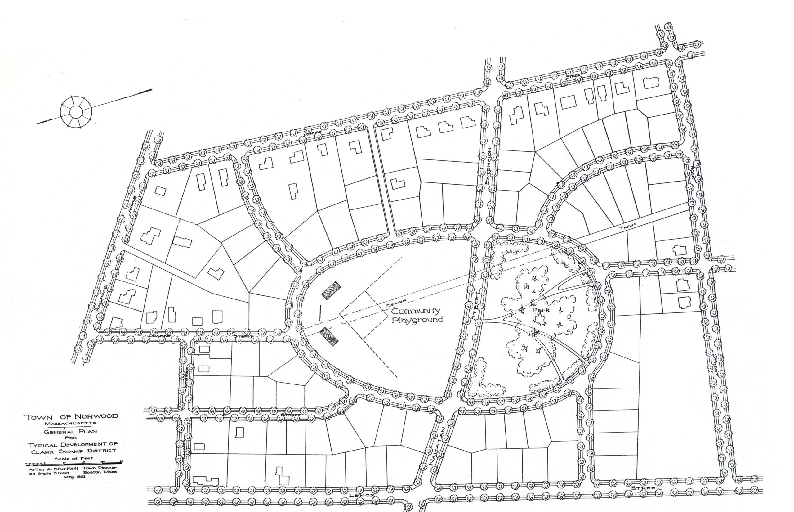
The built-up area of Norwood is gradually approaching the margins of the Clark Swamp district. Under good or bad planning this entire neighborhood is destined to be crossed by streets and built up with dwellings. The cost of this work will be borne inevitably by the citizens of the Town. If good planning is applied…
-
1923 Planning Board Report-Vicinity of High Bridge

The complicated and dangerous arrangement of roadways, railway tracks for electric and steam cars, in combination with a narrow underpass in the High Bridge district illustrates forcibly the costly results of allowing important road junctions to “happen by chance.” It is true that these junctions were created at a time when traffic in this neighborhood…
-
1923 Planning Board Report-Plan For Parkway
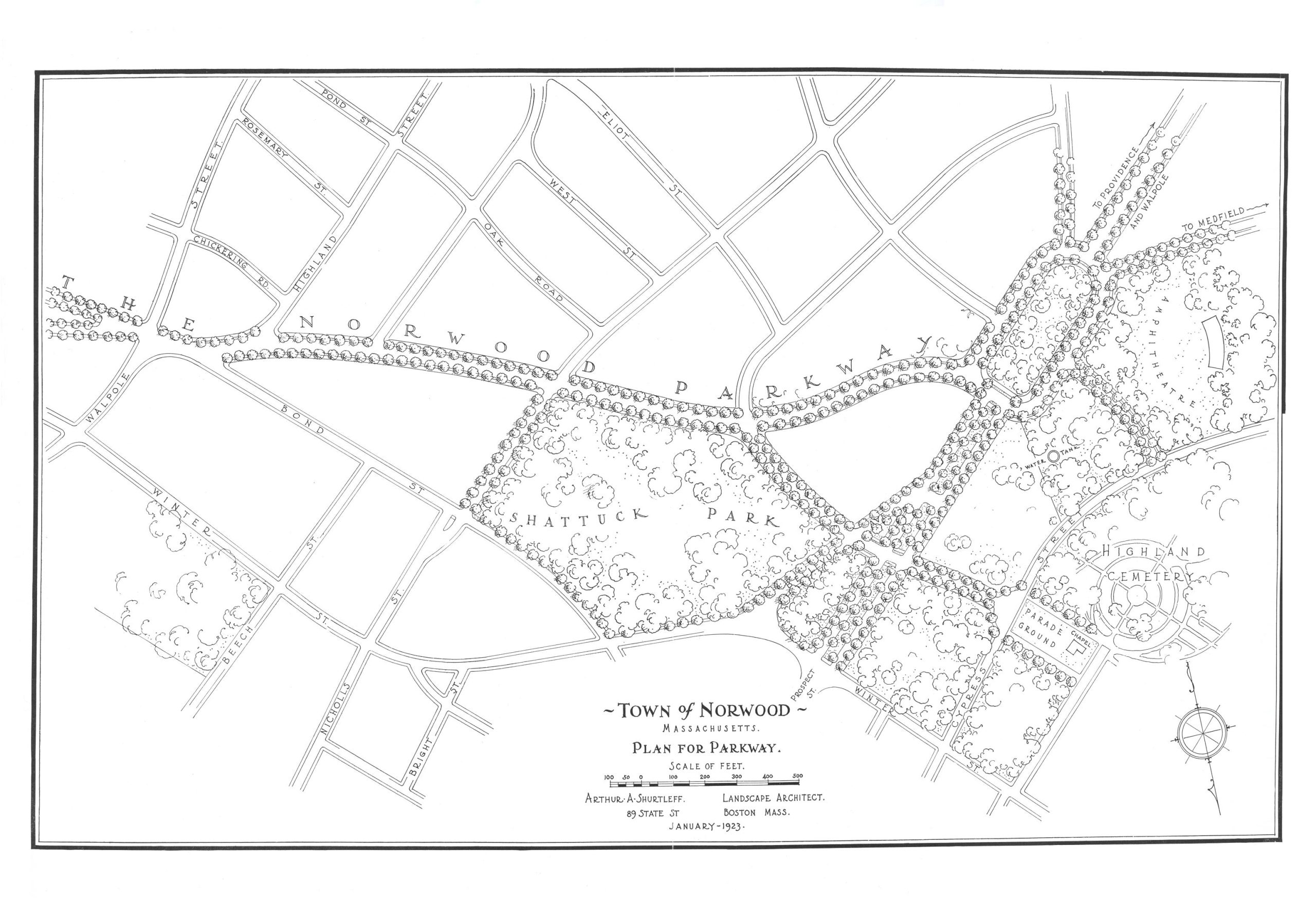
Discover more from Norwood Historical Society Subscribe to get the latest posts sent to your email. Type your email… Subscribe
-
Planning Board Records Remain Largely Missing After Eighteen Months-July 18, 1991
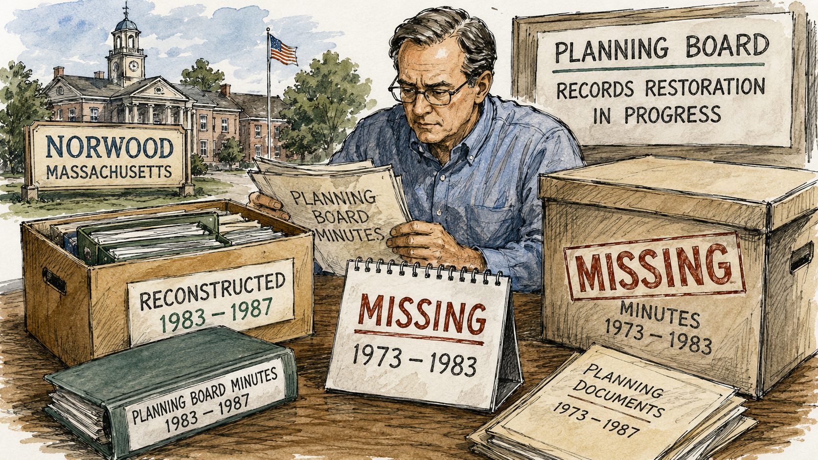
Minutes from 1973 to 1983 remain missing, complicating the town’s ability to track official votes and planning decisions from that era.
Discover more from Norwood Historical Society
Subscribe to get the latest posts sent to your email.